
The land

All Africa in one country

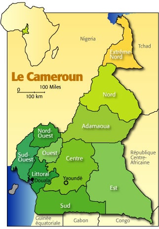
Cameroon is situated in Central Africa, at the juncture of the Gulf of Guinea. It is bound on the North by Chad, on the East by the Central Africa Republic, on the South by Congo, Gabon and Equatorial Guinea and on the West by Nigeria.

Cameroon has a vast geographical diversity characterized by forest, savanna and mountains, alongside a population of over 240 ethnic groups. Its diversity in terrain and culture has led to Cameroon being referred to as “Africa in miniature” or “All Africa in one country“.

Contact us

Topography

The physical geography is varied, with forests, mountains, large waterfalls and deserts, falling into four regions.

  • At the border of the northern Sahel region lies Lake Chad and the Chad basin; further south the land forms a sloping plain, rising to the Mandara Mountains.
  • The central region extends from the Benue (Bénoué) river to the Sanaga river, with a plateau in the north. This region includes the Adamaoua plateau which separates the agricultural south from the pastoral north.
  • In the west, the land is mountainous, with a double chain of volcanic peaks, rising to a height of 4,095m at Mt Cameroon. This is the highest and wettest peak in western Africa.
  • The fourth region, to the south, extends from the Sanaga river to the southern border, comprising a coastal plain and forested plateau. There is a complicated system of drainage. Several rivers flow westwards: the Benue river which rises in the Mandara Mountains and later joins the river Niger, and the Sanaga and Nyong rivers which flow into the Gulf of Guinea. The Dja and Sangha drain into the Congo Basin. The Logone and Chari rivers flow north into Lake Chad.

Vegetation

There is tropical rainforest (including ebony and mahogany) in the hot humid south, with mangroves along the coast and river mouths.

  • The southern coastal plain and south-east plateau also contain the cocoa and banana farms and the rubber and oil palm plantations.
  • The central region has mixed deciduous and evergreen forest. Above the forest zone are drier woodlands, with taller grasses and mountain bamboos. High in the interior and on Mt Cameroon the grasses are shorter.
  • Further north there is savannah bushland, with trees becoming sparse towards the Chad basin. Forest covers 46% of the land area, having declined at 0.9% p.a. 1990-2005. Arable land comprises 13% and permanent cropland 2.6% of the total land area.

Climate

Varies with terrain, from tropical along coast to semiarid and hot in north.

  • In the northern Sahel region, there is a long dry season from October to April, with temperatures varying from cool to very hot.
  • Further south, on the Adamaoua plateau, there are sharp drops in temperature at night.
  • In the south the climate is hot and humid, with two rainy seasons, in September/October and from March to June.

Communications

80,930km of roads, 7% paved. The rail network runs 974km north-south from Ngaoundéré to Yaoundé, with connections between Douala and Yaoundé, and from Douala to Nkongsamba and Kumba. Douala is the principal port, Kribi handles mainly wood exports, Garoua on the Benue river is navigable only during the wet season and Limbo-Tiko is a minor port, severely silted up. International airports are at Douala (10km south-east of the city), Yaoundé (25km from city) and Garoua.

Wildlife

The Waza National Park in the north, originally created for the protection of giraffe and antelope, also abounds in monkeys- screaming red and green monkeys and mandrills- and lions and leopards. There are gorillas in the great tracts of hardwood rainforest in the south and east.

Environment

The most significant issues are overgrazing, desertification, deforestation, poaching, and overfishing.

Regions

Cameroon is a country with several major towns, amongst which are YAOUNDE, the political capital of the country with about one million inhabitants. DOUALA, which is the major economic city, has more than two million inhabitants. The other main towns are GAROUA, BAFOUSSAM, MAROUA, BAMENDA etc.

The country is divided into 10 regions:

Adamawa region

Adamawa region
Regional capital : Ngaoundere
Population: 681 362 inhabitants
Surface area: 63 701km2
Number of Divisions: 5
Density: 10.7inhabitants/km2

Tourist Attractions: Water catchment region of Cameroon, this région is full of crater lakes, cattle ranches, underground minerals, wild animal species and several caves.

Centre region

Centre region
Regional capital: Yaoundé
Population: 2 272 259 inhabitants
Surface area : 68 953 km2
Number of Divisions : 10
Density: 32.96 inhabitants/km2

Tourist Attractions: Seat of the political capital of the country.

So many interesting natural sites such as :

  • The caves of Akok-Bekoe,
  • The monuments of colonial figures such as Charles Atangana,
  • The Chief of the Ewondos,
  • The forest reserve of Ottomo (Ngoumou).

East region

East region
Regional capital: Bertoua
Population: 711 651 inhabitants
Surface area: 109 002 km2
Number of Divisions: 4
Density: 6.53 inhabitants/km2

Tourist Attractions: Visitors can undertake to cross the vast forests that cover this région. The visitor can easily get into camps set up for pygmies, enjoy the biodiversity in the Dja reserve and get a view of the Gbaya and Maka cultures.

Far North region

Far North region
Regional capital: Maroua
Population: 2 553 389 inhabitants
Surface area: 34 263 km2
Number of Divisions: 6
Density: 74.52 inhabitants/km2

Tourist Attractions: Apart from the numerous wild animals which make this région a pleasurable destination for hunting, there is a wide variety of traditional rulers’ palaces, lunar landscape in Kapsiki, caves and lakes with a high concentration of hippopotamus, handicraft shops and horse displays.

Three national parks in this region namely;

  • The national park of Kalamaloué at Kousseri,
  • The national park of Waza at Waza,
  • The national park of Mozogo at Koza.

Littoral region

Littoral region
Regional capital: Douala
Population: 1 861 463 inhabitants
Surface area: 20 248 km2
Number of Divisions: 4
Density: 91.93 inhabitants/km2

Tourist Attractions: The ‘ngondo’ festival is deeply routed here, and other seaside pastimes abound as the indigenes of this région celebrate their intimate relation with water. The entry point into the country for most visitors and harbours a lot of historic monuments. Natural attractions such as the waterfalls of Ekom Kam, lake Ossa and large commercial plantations.

North region

North region
Regional capital: Garoua
Population: 1 145 038 inhabitants
Surface area: 66 090 km2
Number of Divisions 4
Density: 17.33 inhabitants/km2

Tourist Attractions: The visitor has a wide variety of options, ranging from national parks, hunting area, horse displays, traditional palaces to the attractions of the Benoué river with a dam at Lagdo and several archaeological sites where fossil remains of dinosaurs have been found.

The national parks here include those of the Benoué, Boubandjida and Faro.

North West region

North West region
Regional capital: Bamenda
Population: 1 702 559 inhabitants
Surface area: 17 300 km2
Number of Divisions: 7
Density: 98.41 inhabitants/km2

Tourist Attractions: Hilly and mountainous région with grass field landscape, the visitor here has a wide variety of traditional palaces, waterfalls, crater lakes, handicraft shops and other cultural artefacts which make it a regular tourist destination.

West region

West region
Regional capital: Bafoussam
Population: 1 843 518 inhabitants
Surface area: 13 892 km2
Number of Divisions: 8
Density: 132.7 inhabitants/km2

Tourist Attractions: Mountainous région with many traditional palaces, crater lakes and colourful funeral ceremonies (between the months of November and February every year), and the ‘ngoun’, a great annual festival of the Bamoum people.

South region

South region
Regional Capital: Ebolowa
Population: 514 336 inhabitants
Surface area: 47 191 km2
Number of Divisions: 4
Density: 10.9 inhabitants/km2

Tourist Attractions: Area with dense forests and small islets, visitors here can also enjoy the beaches along the coast and the Lobe waterfalls. There are also abundant reserves of sea food.

South West region

South West region
Regional capital: Buea
Population: 1 153 125 inhabitants
Surface area: 25 410 km2
Number of Divisions: 6
Density: 45.38 inhabitants/km2

Tourist Attractions: Home of the highest Mountain in the country and in West Africa, Mount Cameroon. The coastline here also has attractive beaches. Further inland, the Korup national park has a wide variety of rare animals and trees.

Find more about “Cameroon – all Africa in one country” by visiting:
www.cameroun-infotourisme.com

Contact us